Bridging Raw Data with Actionable Insights for a Sustainable Future.

AgBoost Tech Consultancy (ATC) builds AI-enabled geospatial and satellite intelligence platforms. We convert complex field-level data into scalable, measurable decision systems for the agriculture, utilities, and infrastructure sectors.

Our Promise

Delivering field-tested technology

and ground-level implementation

that drives real Return on Investment (ROI)

for your operations.

AgBoost Tech Consultancy builds AI-enabled geospatial and satellite intelligence platforms that convert field-level data into scalable, measurable decision systems for Precision agriculture and infrastructure sectors.

AgBoost Tech Consultancy (ATC) is an India-based Geospatial and AI-driven technology firm focused on building intelligent decision-support systems for agriculture, utilities, and infrastructure sectors. We specialize in integrating satellite imagery, IoT sensor networks, spatial analytics, and predictive modeling to convert complex field data into measurable operational outcomes.

ATC operates at the intersection of:

  • Geospatial Intelligence (GIS & Remote Sensing/Aerial Image). 
  • Artificial Intelligence & Machine Learning
  • Quantum Technology.
  • IoT-enabled real-time monitoring
  • Enterprise system integration
  • Green Energy :AgriPV and Carbon Credit Our work includes precision agriculture deployments, desert agroforestry monitoring, soil moisture intelligence systems, and infrastructure spatial analytics.

We focus on scalable, field-validated solutions designed to improve productivity, optimize resource use, and enhance sustainability. With over two decades of domain expertise in GIS, enterprise IT architecture, and utility digital transformation, ATC combines deep technical capability with real-world implementation experience.

Our Solutions

Precision Agriculture Technologies & Climate Resilience

Intelligent Infrastructure & Utilities (Power & Smart Grids)

Green Energy & Carbon Ecosystems

Enterprise IT & Digital Transformation

Core Technologies

Geospatial Intelligence & Remote Sensing

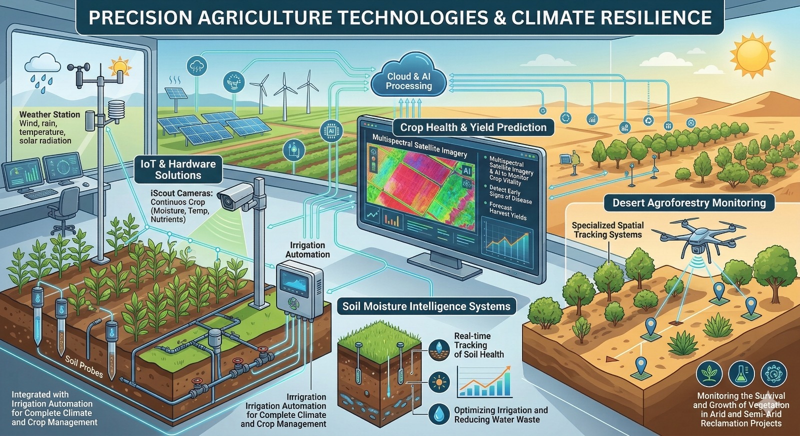
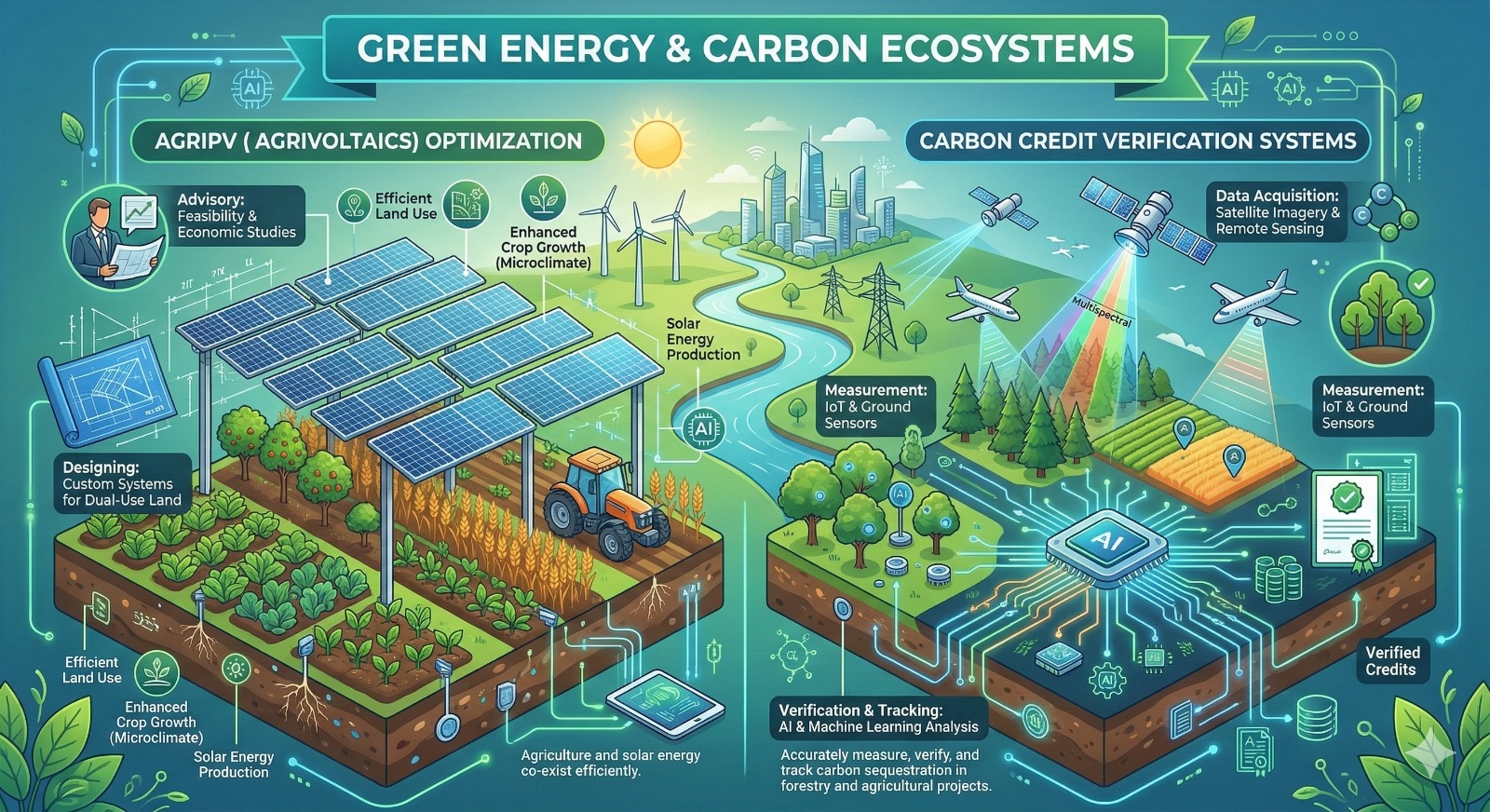
Transforming satellite, aerial, and drone imagery into actionable spatial analytics using advanced Geographic Information Systems (GIS).

Artificial Intelligence & Predictive Modeling

Utilizing AI and Machine Learning models to detect patterns, forecast environmental shifts, and automate anomaly detection.

IoT-Enabled Real-Time Monitoring

Deploying robust IoT sensor networks that capture real-time, ground-level data—from harmonic sensors to soil moisture levels.

collaborations

    Book you appointment.

    Ready to translate field-level data into real ROI ?

    Get in touch with our team to discuss strategic partnerships, pilot projects, or digital transformation for your operations..

    Contact Us